
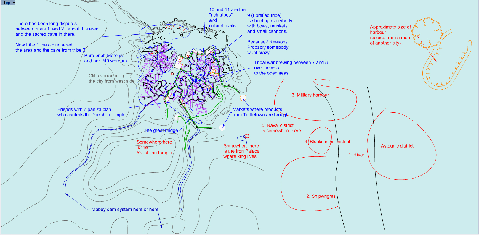
Today I added elevation to the city map – it will affect the shape and exact location of future city districts. In relation to this, do you remember the first NPC I made for the city, Yaxchila – a lichgod who still lives in his ancient temple palace and is visited by pilgrims from all surrounding lands to make pacts with him and the Twice Plague (the major deity of diseases and healing). Yaxchila was once, in ancient times before the Itza kingdom, fleets, and iron trade, the ruler of this city, which means that the city has been here for a very long time. But Yaxchila’s ancient city was quite different – much smaller and not the capital of any empire.

Yaxchila’s ancient city was surrounded by walls and fortifications – I placed Yaxchila’s palace itself on a mountain, and natural mountain streams ran on both sides as a defense. This mountain peak was essentially half of the ancient city of Yaxchila – there were temples, palaces, where the elite, priests and warriors lived. To the south and west of this is rocky jungle that is impenetrable to any enemy (except for two deepened ravines – these will have some walls and/or gates in the future). This mountain peak district is also almost the only area where a of ancient Yaxchilan architecture has been preserved, the rest of the city has been rebuilt over the centuries.
But where was the rest of the ancient city of Yaxchila? The most logical thing seems to be that it’s part of Turtletown, which means that it needs to be redesigned a bit – the city of Yaxchila was fortified, so some ancient wall fragments or city district shapes may have been preserved from that time and are hinted on the map. Like when you visit medieval European cities where the central ring roads often mark the medieval city walls.


I also included cliffs running through the city. These cliffs also have remnants of the ancient city of Yaxchila. Additionally, this creates an interesting situation where the city is divided by cliffs, so the differences between the two sides may be even greater. Only two roads and canals connect the two sides of the city, these could become the starting point for many problems.
In addition, there must be an Asteanic district – after all, Asteanic merchants and the iron they brought was the source of power for the Itza Empire. Knowing the Asteans’ imperialistic nature and considering that the Itza dynasty has remained in power for a continuous 700 years, we can deduce that the Asteans must have been separated from the locals from the beginning – otherwise, they would have had the opportunity to carry out some kind of coup. Maybe on the other side of the river? That’s a good starting point.


